Published On Apr 23, 2021
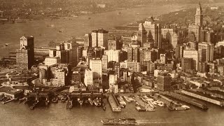
The best and most beautiful 3D maps of New York City, a cartographer’s dream!
Hours of painstaking work would have gone into drawing each of these maps, each by hand and with a 3D bird’s eye aerial view of New York, Brooklyn, Hoboken and Harlem.
With views of The Battery, Hudson River, and all the way up to Harlem. Follow the map over The East River across to Brooklyn. You can spot all the landmarks such as Central Park and Brooklyn Bridge. Only one is missing - the Statue of Liberty. Aw shucks.
You’ll also note something else is missing. Bridges.
The first one to make an appearance was the Brooklyn Bridge, the oldest suspension bridge, in 1883.
Join us as we zoom around the maps in great detail and see places as they were over a hundred and fifty years ago.
Enjoy some of the most beautiful historical views of NYC that you’ll ever see with these old 3D maps of New York City.
You can download each of these maps for free! Here:
Manhattan 1865
https://www.loc.gov/resource/g3804n.p...
Brooklyn 1870
https://www.loc.gov/item/75694750/
Manhattan 1870
https://www.loc.gov/item/75694809/
New York And Brooklyn 1875
https://www.loc.gov/item/75694808/
Manhattan 1879
https://www.loc.gov/item/97683570/
Manhattan 1867
https://www.loc.gov/item/76695280/
Prohibition Park 1898
https://www.loc.gov/item/2010588786/
Hoboken 1904
https://www.loc.gov/item/75694727/
Harlem River 1897
https://www.loc.gov/item/75694804/
Like, subscribe and click the bell.
See more great vids like this on our channel!
/ yestervid
http://www.yestervid.com
/ yestervid
/ yestervid