Published On May 26, 2021
Breathtaking old maps of Los Angeles from 1871 to 1948 show the jaw dropping speed of development of the city over the last 150 years, narrated with an insightful history of Los Angeles.
These maps are a window in the history of Angelinos over the last century and a half. Also, they are all exquisitely hand-drawn maps in 3D bird's-eye perspective, giving you a beautiful aerial view of old Los Angeles.
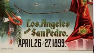
There are 20 maps bringing the history of Los Angeles to life and they cover Downtown Los Angeles from 1871 to 1935, Santa Monica, Wilmington, Azusa, San Pedro, Pasadena, Pomona, Santa Barbara and Catalina Island.
They also cover important historical events of the early days, such as settlers, the electrical supply, oil fields and ranchos.
Also mapped out is the entertainment industry of the day, with a 'map to the stars' as well as all the famous studios, clubs and entertainment venues.
Here's what you'll see:
1:02 Historical Events Map 1929
2:51 Map of Los Angeles 1871
4:21 Map of Santa Monica 1877
5:52 Map of Santa Catalina 1948
8:23 Map of Wilmington 1877
9:57 Map of San Pedro 1905
11:23 Map of Los Angeles 1877
13:55 Map of Pomona 1886
15:49 Map of Azusa 1887
16:34 Map of Brooklyn Heights 1891
17:56 Map of Los Angeles 1894
21:01 Map of Santa Barbara 1898
22:52 Map of Pasadena 1903
25:22 Map of Los Angeles 1909
28:08 Oil Fields of Los Angeles 1922
29:39 Los Angeles Wonder City 1932
32:08 Edison Electrical Map 1935
35:39 Los Angeles 1894 Looking South
Like, subscribe and click the bell.
See more great vids like this on our channel!
/ yestervid
http://www.yestervid.com
/ yestervid
/ yestervid