Published On Jul 18, 2014
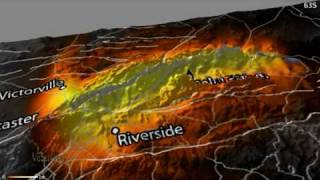
This animation shows, in exaggerated terms, how the surface of the southern Central Valley of California deformed from the period 2007 to 2011. Interferometric data from the Japanese ALOS PALSAR imaging radar was used to measure the deformation, shown in color overlaid on an ASTER image. The large subsidence "bowl" that developed over this time period was caused by withdrawal of groundwater, causing subsurface layers to compact. Interferometric synthetic aperture radar, or InSAR, can be used to monitor subsidence in order to prevent groundwater overdraft and irreversible compaction of aquifers. ALOS PALSAR data is copyright JAXA/METI and was provided by the GEO Supersites and the U.S. Government Research Consortium datapool at the Alaska Satellite Facility.
For more information regarding this animation, please contact Tom G. Farr, Zhen Liu, or Vincent Realmuto, at the Jet Propulsion Laboratory, Pasadena, Calif.
Image Credit:
NASA/JPL-Caltech