Published On Premiered Jan 30, 2021
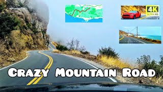
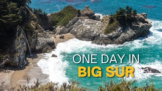
Scenic California Drive. Big Sur. Monterey County, California, USA
Driving tour of Big Sur ocean cliffs on the northbound California state route 1 (Pacific Coast Highway)
This portion of Pacific Coast Highway is designated as US Scenic Highways Network
This driving tour takes you from Pacific Valley to Carmel-By-TheSea along CA-1 Pacific Coast Highway
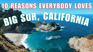
Big Sur Coast Highway is a section of California State Route 1 through the Big Sur region of California that is widely considered to be one of the most scenic driving routes in the United States, if not the world.
It is both a National Scenic Highway and a California Scenic Highway, and was described by Australian painter Francis McComas as the "greatest meeting of land and water in the world."
Condé Nast Traveler named State Route 1 through Big Sur one of the top 10 world-famous streets, comparable to Broadway in New York City and the Champs-Élysées in Paris. The road itself is sometimes seen as a destination for visitors.
The Pacific coast road trip is a thing you should probably do at least once in your lifetime.
The views from CA-1 route ocen cliffs are pretty good
The Big Sur portion of Highway 1 is generally considered to include the 71-mile (114 km) segment adjoining the unincorporated region of Big Sur between Malpaso Creek near Carmel Highlands in the north and San Carpóforo Creek near San Simeon in the south.
Prior to its completion, the California coast south of Carmel and north of San Simeon was one of the most remote regions in the state, rivaling at the time nearly any other region in the United States for its difficult access.
In 1920, the 26 mi (42 km) trip from Monterey to the Pfeiffer Ranch in the Big Sur valley in a light spring wagon pulled by two horses could be completed in about 11 hours. A lumber wagon pulled by four horses could make the trip in 13 hours.
The rough road ended in present-day Big Sur Village and could be impassible in winter. There was no road beyond the Pfeiffer Ranch, only a horseback trail connecting the homesteads to the south.
The highway was first proposed by Dr. John L. D. Roberts, a physician who was summoned on April 21, 1894 to treat survivors of the wreck of the 493 tons (447 t) S.S. Los Angeles (originally USRC Wayanda), which had run aground near the Point Sur Light Station about 25 miles (40 km) south of Carmel-by-the-Sea.
The ride on his two-wheeled, horse-drawn cart took him 3 1⁄2 hours, a very fast trip for the day.
Construction began in 1921, ceased for two years in 1926 when funding ran out, and after 18 years of construction, the Carmel–San Simeon Highway was completed in 1937.
The route was incorporated into the state highway system and re-designated as Highway 1 in 1939.
Along with the ocean views, this winding, narrow road, often cut into the face of towering seaside cliffs, dominates the visitor's experience of Big Sur.
The stunning views, redwood forests, hiking, beaches, and other recreational opportunities have made Big Sur a popular destination for about 7 million people who live within a day's drive and visitors from across the world.
The road is subject to closure during heavy storms.
The drive along Highway 1 has been described as "one of the best drives on Earth", and is considered one of the top 10 motorcycle rides in the United States.
Highway 1 was named the most popular drive in California in 2014 by the American Automobile Association.
Condé Nast Traveler named State Route 1 through Big Sur one of the top 10 world-famous streets, comparable to Broadway in New York City and the Champs-Élysées in Paris.
Most of the nearly 7 million tourists who currently visit Big Sur each year never leave Highway 1, because the adjacent Santa Lucia Range is one of the largest roadless coastal areas in the entire United States; Highway 1 and the Nacimiento-Fergusson Road offer the only paved access into and out of the region.
The beauty of the scenery along the narrow, two-lane road attracts enormous crowds during summer vacation periods and holiday weekends, and traffic is frequently slow.
Visitors have reported to the California Highway Patrol hours-long stop-and-go traffic from Rocky Creek Bridge to Rio Road in Carmel during the Memorial Day weekend.
The highway winds along the western flank of the mountains mostly within sight of the Pacific Ocean, varying from near sea level up to a 1,000-foot (300 m) sheer drop to the water. Most of the highway is extremely narrow, with tight curves, steep shoulders and blind turns. The route offers few or no passing lanes and, along some stretches, very few pullouts.
The sides are occasionally so steep that the shoulders are virtually non-existent.
Dash Cam Tours
#RoadTrip #BigSur #PCH
• California storm washes out part of H...
Dashcamtours.com
Check out my second channel with scenic walking tours:
/ povwalks
Follow on Twitter:
https://twitter.com/DashCamToursDot?s=09