Published On Nov 25, 2020
Disrupted jet streams have made weather worldwide more extreme.
Watch the full conversation: https://tdc.video/programs/how-earths...
Dr. Jennifer A. Francis: https://www.jenniferafrancis.com/
https://www.woodwellclimate.org/staff...
My new membership site: https://tdc.video/catalog
Video by Bryce Plank
Subscribe to TDC:
/ thedailyconversation
Warming Arctic air is disrupting the jet stream, causing more extreme weather: heatwaves, droughts, tornados, category 6 hurricanes, rainfall events, floods, wildfires, snowstorms, blizzards.
Full transcript:
(Bryce) The region experiencing the fastest warming is the Arctic. At the same time, areas like the Eastern United States have been experiencing colder than normal temperatures at times during the winter. This seemingly strange phenomenon is happening because warming arctic air is causing the jet stream, that regulates weather here in North America, to behave in more extreme ways.
(Dr. Francis) Because of the effect of the rapid arctic warming on the jet stream, the jet stream being this river of wind that encircles the northern hemisphere. It takes these north-south swings as it as it goes around the northern hemisphere. And one of the ways the rapid arctic warming is affecting the jet stream is to make those big north south swings be big more often. And when we have one of those big southward dips in the jet stream during the winter it allows the cold air from the arctic to penetrate farther south. And we see this happening more frequently over the Eastern U.S. and over Eastern Asia in connection with this rapidly warming arctic. When that temperature difference is really strong then that's when we see very strong jet streams. And when it's weaker, like when the arctic warms much faster than the areas farther south, then we tend to see the jet stream weaken and when it's weaker it tends to want to take these bigger north-south swings. They tend to get stuck in place for days and sometimes even weeks. Whatever weather you're experiencing relative to your position in that wave, you tend to have those same weather conditions for a long time.
(Bryce) The jet stream is also slowing down in the summertime causing three consecutive years of unprecedented hurricanes: 2017's Harvey, 2018's Florence, and 2019's Dorian. Each storm got "stuck" and dumped record rainfall on Houston, the Carolinas, and the Bahamas.
(Dr. Francis) The slow movement of Dorian was more related to the fact that in summer time we're seeing the jet stream weaken over the continents pretty dramatically. And the jet stream winds create the highs and the lows that steer hurricanes. In that particular case, there was a very weak high pressure area sitting off Cape Hatteras for several days and it sort of blocked it from heading north. And then that high pressure weakened and it allowed Dorian to finally start moving northward. So the paths of hurricanes depend completely on what the jet stream is doing. And when those winds in the atmosphere are very weak, it makes it very hard to forecast where a hurricane's going to go.
(Bryce) And a couple years before that Harvey just dumping.
(Dr. Francis) Yep.
(Bryce) Feet of-
(Dr. Francis) Yep, just a year before.
(Bryce) Just sitting over Houston. So is that what we have to look forward to?
(Dr. Francis) I think we need to look forward to having it happen more often for sure. And there's been a couple recent papers that have actually documented this trend. So it does appear that hurricanes are tending to be slower. And so the tendency for these storms to just sit in one place for a while is increasing, and it makes lots of sense--it all fits the story.
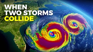
(Bryce) Is there a hurricane beyond a category five that we could see?
(Dr. Francis) Yeah, there's some discussion of creating a cat six.
(Bryce) Wow.
Dr. Francis) Yep there is talk of that. Going back to that water vapor I was talking about. So when the ocean temperatures are really warm there's also a lot of water vapor in the atmosphere and that's the main fuel to generate a hurricane. There's a lot of other factors, but the main one that you need for a hurricane to form, and to become strong, is that very warm water and a lot of moisture in the atmosphere.
My full, wide-ranging conversation with Dr. Francis is available to watch now, ad-free, through the link below on my new premium site. Membership gets you full early access to every episode of the Climate Change Solutions show and allows me to continue making them in these uncertain times. The small fee also unlocks links to all the research I do for each episode, so you can easily venture down some of the many rabbit holes I've been exploring. Thanks for watching. For TDC, I'm Bryce Plank