Published On Oct 24, 2023
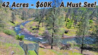
180 Acres of MONTANA Ranch Land for Sale with a Creek flowing through 3/4 of a Mile through the Property. This Parcel borders 640 Acres of BLM Land along the entire Southern Boundary.
Montana | 180 Acres | $60k
View Property Details: https://www.landio.com/listing/mt-ros...
For Question & To Purchase This Property, Please Call or Text LANDIO Anytime at 866-8-LANDIO (866-852-6346)
Please Reference LANDIO Property ID: MT_Rosebud_00001
Do You Have Property to SELL? Visit: http://SELLwithLANDIO.com
Watch the Moise Valley Ranch Video: • MONTANA Ranch Land for Sale 2,425 Acr...
Check Out the Jetson One: https://www.jetsonaero.com/
🔥 Please Subscribe 👉 https://www.youtube.com/landio?sub_co...
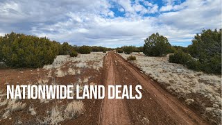
The nickname Big Sky Country perfectly fits this Property featuring pristine Montana rangeland with live water. Even better, it borders 640 acres of beautiful BLM land along the southern boundary. Take in scenic creek cliff vistas, quiet riverbanks, and endless grassy plains dotted with native shrubs. Rattlesnake Creek winds diagonally across the central portion of the property.
For the hunter or rancher envisioning life off the grid, imagine building a home or cabin atop the ravine overlooking the creek and Montana's rugged plains beyond. Nothing beats catching a vibrant sunset or watching a thunderstorm roll in over the vast prairie. White blankets of snow provide protection for small game in the winter. This property offers a unique side of Montana that is just as breathtaking as the mountains.
The property is a prime location in eastern-central Montana for those who want unhindered natural beauty, zero restrictions, and fantastic land opportunities.
Located in Game Management Unit (GMU) 701, this expansive wildlife haven is known for trophy elk, antelope, and mule deer. The large creek, mild climate, and open plains attract wildlife year-round.
Nearby Deadman’s Reservoir is primarily used for agricultural irrigation, but it’s a nice spot to fish, kayak, or paddleboard, too. This local lake may not attract many out-of-state visitors—and that’s a good thing! It’s one of the few bodies of water in central-eastern Montana stocked with rainbow and brown trout. The less crowded conditions and large surface area mean larger fish.
The lush, serene banks of the flowing Musselshell River also offer opportunities to fish for large brown trout and smallmouth bass.
Jump ahead years later to the early 1800s when Lewis & Clark set out on the Missouri River and eventually abandoned a boat near Montana’s Great Falls. Helena-Lewis & Clark National Forest in Helena, MT, is a great place to learn about history, hike, cross-country ski, fish, bike, camp, watch wildlife, and more. The forest showcases Great Falls and the Lewis & Clark Historic Trail, opening up to Montana’s Rocky Mountain Front. This 2.8 million-acre forest is massive and spans 17 counties, so there’s no shortage of exploration and outdoor adventures.
Electricity & Accessibility
There’s electricity 2.7 miles to the West of the property.
To reach the property from SH 12, follow this route: Begin on Musselshell River Rd., then proceed to Oil Well Rd., and finally High Five Rd. This path leads to a dirt road accessible through an unlocked gate, which historically provided access from the East. Unfortunately, this dirt road is currently impassable due to washout, rendering it inaccessible even to 4-wheel drive vehicles. Regrettably, we lack information regarding easements or alternative access options for the property, which explains the reduced price.
The wide wilderness of the open prairie has an allure all its own. From ranching to land investment and off-grid living, this breathtaking rangeland with creek access offers both beauty and opportunity. Don’t miss it! Place a deposit today to claim it.
Property Specifications
LANDIO Property ID: MT_Rosebud_00001
Parcel Size: 180 Acres M/L
APN: 29215311301011200
Legal Description: Township 12 North, Range 31 East of the Principal Montana Meridian, in Rosebud County, Montana., Section 11: 1/2SW1/2 , SE1/4NW1/4, S1/2NE1/4NW1/4
Property Taxes: $40.68 per year
Title: Free & Clear
Conveyance: Warranty Deed
Nearby Towns & Cities
Approximate Distance to Nearby Cities & Points of Interest
18.1 miles to Melstone, MT : Population 125
52.7 miles to Roundup, MT : Population 1,740
102 miles to Billings, MT : Population 117,000
104 miles to Deadman's Basin Reservoir
107 miles to Pictograph Cave State Park
121 miles to Miles City, MT : Population 8,350
128 miles to Lewis & Clark National Forest
181 miles to Fort Peck Recreation Area
227 miles to Bozeman, MT : Population 56,000
217 miles to Bighorn Canyon National Recreation Area
GPS Coordinates (approximate)
Northwest Corner: 46.821403, -107.790961
Northeast Corner: 46.826913, -107.780423
Southeast Corner: 46.814207, -107.780372
Southwest Corner: 46.814171, -107.785651
Center Point: 46.820194, -107.784639
#land #landforsale #montana